geo109
Geography 109:
Digital Mapping
Mapping 4: Introduction to QGIS: Installation Instructions
Mapping 4 - Install QGIS - Part 1 - Part 2 - Part 3
This exercise involves a mapping process commonly used by professional cartographers. As such, you’ll use data in new ways—be patient! By engaging more deeply with data, you’ll start to understand the moving parts of making digital maps that are often hidden from their users.
In particular, this assignment will introduce data preparation in Microsoft Excel and visualization in QGIS, a free and open-source software (FOSS). Before week 6, download QGIS to your computer. In lab, you will import county geometry.
This assignment will take three recitation sections to complete; therefore it is crucial that you attend each recitation and arrive on time.
Grading and Deliverables
The assignment is worth 50 points. Grading will be based on a Word document/PDF that you will upload to Canvas. This document should include:
- Your two exported maps (20 points),
- Your responses to the questions in each part (30 points)
Due: Consult the syllabus schedule for the due date of this assignment.
Note: You must come to lab week 6 with QGIS installed.
Be conscious of saving and storing your data, either on a thumbdrive, space you know is secure on the UK drive, on cloud storage, or your laptop. It is your responsibility to save your data securely.
Before you begin (do this before week 6): Install QGIS
If using Microsoft Windows…
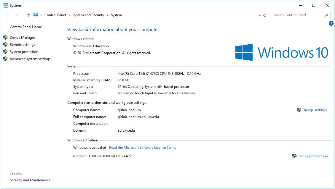
- Determine if you are a running 32- or 64- bit version of Windows by pressing WIN+X (windows key plus X) and selecting “system.”
If using Windows 7 or XP, visit http://windows.microsoft.com/en-us/windows/32-bit-and-64-bit-windows#1TC=windows-7/ for directions.
- Open a web browser and go to https://www.qgis.org/en/site/forusers/download.html.
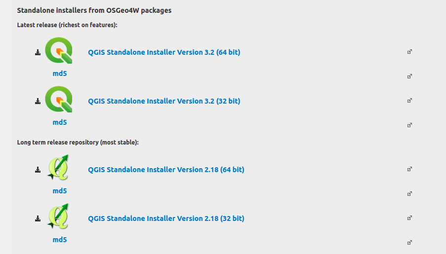
- Download and run the appropriate installer (2.18 is the most stable and least likely to give you issues). The default settings should work just fine for our purposes.
If using Mac OS X…
Note: You must follow the download instructions from the QGIS download site carefully. Use of QGIS 2.18 is recommended.
-
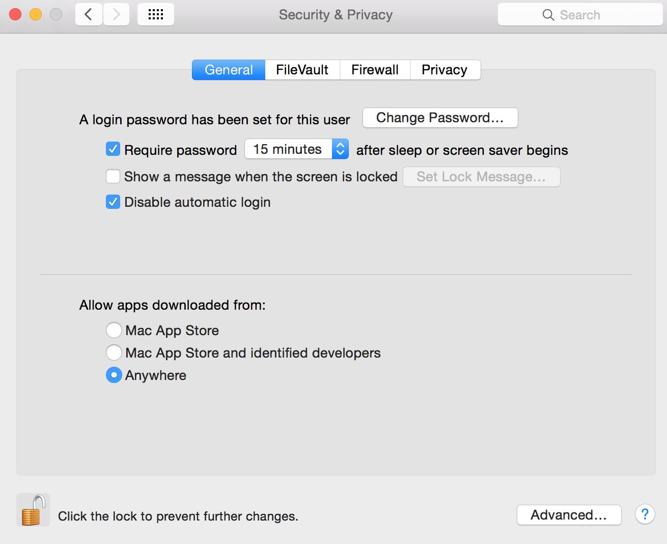
First, because Macs are configured to not accept downloads that are not from the Mac App Store, you will probably have to change their security settings:
- Go to System Preferences > Security & Privacy > Allow apps downloaded from:
- Anywhere
- Go to System Preferences > Security & Privacy > Allow apps downloaded from:
-
Open a web browser and go to https://www.qgis.org/en/site/forusers/download.html.
-
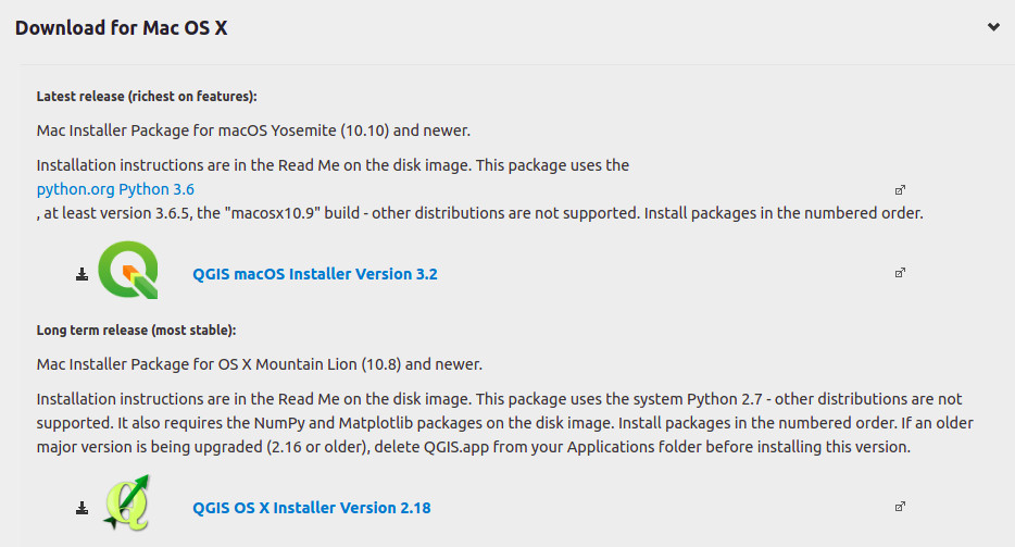
Click “Download for Mac OS X.”
-
Download the installer for QGIS 2.18.
-
Run the downloaded installer. When opening the
.dmgfile, it is important that you install the packages sequentially:- Install GDAL First
- Install NumPy Second
- Install matplotlib Third
- Install QGIS Last
Note: Watch this video starting at time 3:16 to see an installation of QGIS 2.18 for Mac.
Mapping 4 - Install QGIS - Part 1 - Part 2 - Part 3